English etiketine sahip kayıtlar gösteriliyor. Tüm kayıtları göster

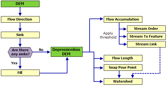
Drainage modeling case study

Flow accumulation

Hydrology

http://www.spatialanalysisonline.com/output/topics/DrainageModelingCaseStudy.html

Esri CityEngine 2012

http://www.esri.com/software/cityengine

Coming Soon
Download the Esri CityEngine brochure [PDF].
Register for a free trial.

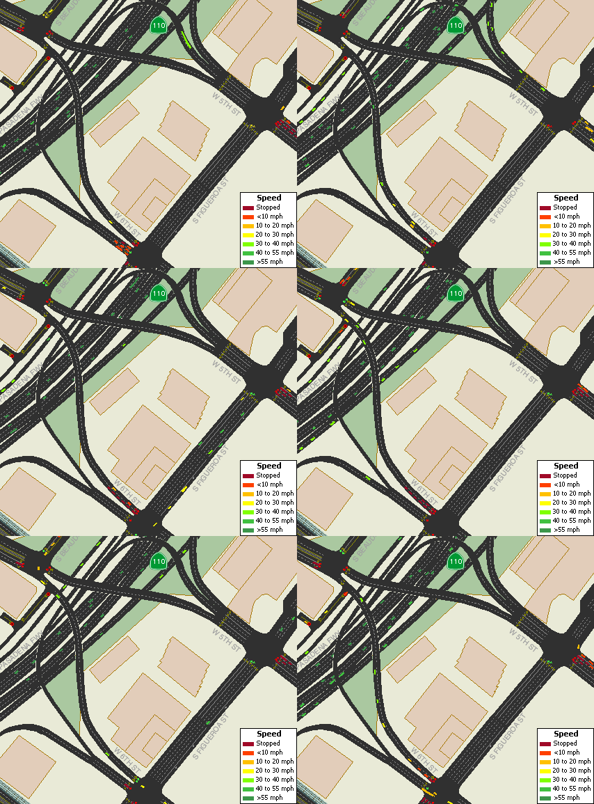
Traffic Simulation


http://www.caliper.com/transmodeler/default.htm

Remove Z- and/or M-values from a feature class

http://support.esri.com/en/knowledgebase/techarticles/detail/35818

Procedure

Browse to ArcToolbox > Conversion Tools > To Geodatabase.
Open the Feature Class to Geodatabase (multiple) tool.
Add all the feature classes into the Input Feature Class parameter.
Select an Output Geodatabase.
Click the Environments button at the bottom of the tool dialog box.
Expand the General Settings.
For the parameter, Output has Z Values, change the value to Disabled.
For the parameter, Output has M Values, change the value to Disabled.
Click OK in the Environments dialog box.
Click OK to execute the geoprocessing tool.

National Historical Geographic Information System (NHGIS)

https://www.nhgis.org/

The National Historical Geographic Information System (NHGIS) provides, free of charge, aggregate census data and GIS-compatible boundary files for the United States between 1790 and 2010.

sdelayer register 9.3


sdelayer -o register -l KBBSREHBER,GEOM -e p -t SDO_GEOMETRY -g NONE -u ARCCBS -p ARCCBS -C CBNO -P HIGH

sdelayer -o register -l UNIV_YOL,GEOM -e l -t SDO_GEOMETRY -g NONE -u ARCDATA -p K -C CBNO -P HIGH

sdelayer -o alter -l UNIV_MAHALLE,GEOM -u ARCDATA -p ARCDATA -E calc -g NONE 


=======


C:\>sdelayer -o register -l UNIV_YOL,GEOM -e l -t SDO_GEOMETRY -g NONE -u ARCDATA -p K -C fid -P HIGH

sdelayer -o register -l UNIV_MAHALLE,GEOM -e a -t SDO_GEOMETRY -g NONE -u ARCDATA -p K -C fid -P HIGH

ArcGIS For AutoCAD


ArcGIS for AutoCAD
Download
If you missed anything in the live broadcast, watch the recorded seminar.
If you are interested in additional training, visit Esri Training for detailed course descriptions, class schedules, and registration information.

32-bit Oracle database software on a 64-bit MS Windows OS

http://mrothouse.wordpress.com/2010/11/11/32-bit-oracle-database-server-is-not-certified-on-windows-x64/


Cause
Installed 32-bit Oracle database software on a 64-bit MS Windows OS which is not supported.

Note: For the Database software, you can ONLY install the x64 version on MS Windows (x64).  You can NOT install the 32-bit version Database software on MS Windows (x64)

Solution
Install 32-bit Oracle database software only on 32-bit MS Windows OS.

Intersect - Create Node

Intersect yolek_kbbsyol_Merge_kirik c:\temp\intersect.shp ALL 0.005 POINT

Creates Nodes


cancel vmware time synchronize


open *.vmx file in notepad 
and add these lines
-------------------
tools.syncTime = "0"
time.synchronize.continue = "0"
time.synchronize.restore = "0"
time.synchronize.resume.disk = "0"
time.synchronize.shrink = "0"
time.synchronize.tools.startup = "0" 
time.synchronize.resume.host = "0"
--------------

Labels - Etiketler

3D (14) 3D Analyst (5) 3D Studio Max (2) ABD (2) About building an SQL expression (1) Access (4) Adding hyperlinks to features (1) Adding OLE DB connections (1) administrative areas (1) Adobe (1) Adobe illustrator (1) Adobe Reader (1) Adobe Reader Analysis Tool (1) aggregate (1) Aggregate Polygons (2) An overview of ModelBuilder (1) An overview of writing geoprocessing scripts (2) analysis (2) Append (4) ArcCatalog (1) ArcGIS (63) ArcGIS 9.3 Map Export PDF (2) ArcGIS Mobile (1) ArcGIS Server (9) ArcGIS Server 9.3 Web Help (1) Arcgis Server 10 (2) Architectural (1) arcscene (3) arcscripts (5) ArcSDE (1) Arcview (1) Arcview ile kml yi shp ye dönüştürme (1) AutoCAD (2) AutoVue (1) Bina Verisini Düzenlerken (2) bölme (1) CAD (3) CAD/GIS (87) calculate (1) canada data (2) CenterPoint (1) Chicago (2) CityEngine (1) CitySurf (5) clip (1) Common line editing tasks (1) Common polygon editing tasks (1) Contour (1) Create Node (1) çevreleyenden bilgi al (2) database (1) Database Browser (1) date (1) definition query (1) demicron (1) Dissolve (1) download (6) dünya (1) dwg (1) Eğim Analizi (1) Eliminate (1) English (67) Erciyes (4) error (1) Esri (2) Eşyükselti (1) etiket (1) Excel (4) export (1) expression (2) Flip (Çizgi Yönünü değiştirir) (2) Free GIS Software (1) freeWRL (2) fwtools (1) fwtools ile kml ve shp arası dönüşüm (1) FWTools Shell (1) Geomedia (14) Geoprocessing Quick Guide (1) geoserver (3) geoserver kurulumu (1) geoserver labeling (2) geoserver labeling not supported with qgis (1) Geoyol u düzenlerken (1) GIS Data (2) GIS Data of America (2) Glonet (1) google (1) group by (1) halihazır (1) hidroloji (1) How Import from CAD (Conversion) works (1) html (1) hydrology (10) hyperlink (1) hystorical GIS (1) ilk karakteri silen sql (1) insert (2) intersect (1) İzohips (1) java (2) kml (2) kml to shp (3) konya (1) label (2) line editing (1) Link (1) links (40) M and Z Values (3) MapBuilder (1) Maplex Label Engine (1) Maps (1) MapShaper (1) Max (1) MBR (1) mdb (1) Mekansal Analiz (1) merge (1) Mimari (1) Mobile (1) multi Geometry (3) multipart to single part (1) multipoint (1) NetCAD (19) netcad Network Lisans İzleyicisi (1) Netcad Program No (1) Netcad TILE (1) NetCAD to Oracle Spatial (5) NetCAD ve ArcGIS farkı (3) netcadde wms oluşturmak için workspace export (1) netgis (1) netgis server (1) Network Analyst (3) Node (1) ObjectID kolonu problemi (1) online wms viewer (1) Oracle (16) Oracle Spatial (3) Oracle veri tabanının yeniden başlatılması (1) output mode (1) Parcel (2) Parcel Editor (1) parsel (1) pdf (3) pdf i html ye dönüştürme (1) pdftohtml (1) PHP (1) point (1) PostGIS (30) Postgresql (8) Postgresql otomatik yedek alma (1) Projection (1) Pyton (1) Raster (2) register (1) Rename (1) RepairGeometry (1) replace (2) Routing (1) sdelayer (1) Select by Location: graphical examples (1) server (1) shape viewer (2) shp (7) shp2sdo (1) single Geometry (3) sld (1) snap (1) social explorer (1) sonra eklenecek (1) Spatial Join (Analysis) (2) spatialanalysisonline (1) Split Line at Vertices (Data Management) (ArcInfo only) (1) Sql (48) SQL reference (1) SRID (1) su yatakları (1) subst (1) subtract (1) sum (1) synchronize (1) Şehir ve Bölge Planlama (1) tablo (1) tablodan tabloya veri aktarma (1) terrain (1) Texas (2) time (1) tin (3) tin edit (1) topology (5) Topology check (2) Traffic Simulation (1) Trafik (1) Transform (1) trim (1) Ulaşım (1) Ulaşım Planlama (1) union (1) Union ve Merge (1) Unregister As Versioned (1) update (2) UrbanSim (1) veri (2) Vermont (1) Versioning (2) vertex lere nokta atar (1) video (17) WFS (2) wirefusion (1) wms (3) wmware (1) wmx (1) Working with Microsoft Access files in ArcGIS (1) Working with Microsoft Excel files in ArcGIS (1) world (1) wrl (1) yol (2) yol kırma (2) Yol Uzunluk (2) yolkır (1) Z değeri edit (1)