Bina Verisini Düzenlerken

bina (poligon)
yol (line)
kapı (line)
amaç: bina tablosuna, yol tablosundaki bilgileri eklemek.
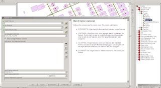
yoldan kapı verisine join işlemi için "Spatial Join" tool unu intersect parametresiyle kullanıyoruz.
kapı verisinden binaya veri aktarırken yine aynı işlemi uygularken,


binalar için alamadığımız "yol ID" si bilgilerini ise, join data işleminin "each point will be given a summary of..." parametresini kullanarak en yakın yol bilgisini aldırıyoruz.


"Geospatial Analysis" el kitabı

http://www.spatialanalysisonline.com/output/

Oracle veri tabanının yeniden başlatılması

ağ problemlerinden dolayı oracle veritabanına ulaşmada problem yaşanıyorsa, yapılması gerekenler:

1. veri tabanını durdur : hizmetler > OracleServiceXE
2. Listener i durdur: hizmetler > Oraclexetnslistener
3. Listeneri başlat
4. veri tabanını başlat

listenerin veri tabanından önce başlatılması önemli

Geoyol u Düzenlerken

-------------------

select OBJECTID, YOL_ADI from KAYSERI_BELNET.GEOYOL
WHERE
YOL_ADI LIKE '%CADDE'
OR
YOL_ADI LIKE '%SOKAK'
OR
YOL_ADI LIKE '%BULVAR'
OR  
YOL_ADI LIKE '%KÜME EVLER'
--------------------
SELECT REPLACE('www.mysql.com', 'w', 'Ww');
Above statement will return 'WwWwWw.mysql.com' as result.
------------
select ACIKLAMA, MAHALLE_ADI, MADI, ESKI_YOL_ADI, YOL_ADI from GEOYOL
WHERE MADI = '0'
OR ESKI_YOL_ADI LIKE '%SOKAK'
OR ESKI_YOL_ADI LIKE '%CADDE'
OR ESKI_YOL_ADI LIKE '%BULVAR'
OR ESKI_YOL_ADI LIKE '%KÜME EVLER'

----------------
---------------
Description
Changes existing data in a table.
Syntax
UPDATE  { table_name  | view_name }
SET { column_name = expression } [ ,...n ]
[ FROM { table_name  | view_name } [ ,...n ] ]
[ WHERE < search_condition > ]
Example
UPDATE table1
SET c1 = 9
UPDATE EXPORT
SET DENEME = '9'
WHERE YOL_ADI = 'KÖSE SK.'
-----------
UPDATE KAYSERI_BELNET.GEOYOL
SET ACIKLAMA = '12345'
WHERE MADI = '0'
OR ESKI_YOL_ADI LIKE '%SOKAK'
OR ESKI_YOL_ADI LIKE '%CADDE'
OR ESKI_YOL_ADI LIKE '%BULVAR'
OR ESKI_YOL_ADI LIKE '%KÜME EVLER'

--------------
select  YOL_ADI, OBJECTID, ACIKLAMA from GEOYOL
WHERE YOL_ADI NOT LIKE '%.'
AND YOL_ADI NOT LIKE '%KAVŞAK'
AND YOL_ADI NOT LIKE '%DÖNEMEÇ'
AND YOL_ADI NOT LIKE '%KÜME EVLER'
AND YOL_ADI <> 'BAĞLANTI Y. '
------------
UPDATE KAYSERI_BELNET.GEOYOL
SET ACIKLAMA = 'YOL_ADI düzeltilecek'
WHERE YOL_ADI NOT LIKE '%.'
AND YOL_ADI NOT LIKE '%KAVŞAK'
AND YOL_ADI NOT LIKE '%DÖNEMEÇ'
AND YOL_ADI NOT LIKE '%KÜME EVLER'
AND YOL_ADI <> 'BAĞLANTI Y. '

-------------
  select  ESKI_YOL_ADI, YOL_ADI, OBJECTID, ACIKLAMA from GEOYOL
WHERE ACIKLAMA = 'YOL_ADI düzeltilecek'
or  ACIKLAMA = 'YOL_ADI düzeltildi'
ORDER BY ACIKLAMA
------------------
  select  * from GEOYOL
WHERE YOL_ADI LIKE ' %'
OR ACIKLAMA LIKE ' %'
OR ESKI_YOL_ADI LIKE ' %'
OR TANITIM_KODU LIKE ' %'
OR TASIT_YAYA LIKE ' %' 
-----------------
  select  YOL_ADI, ACIKLAMA from GEOYOL
WHERE ACIKLAMA LIKE 'YOL_ADI%'
ORDER BY ACIKLAMA DESC
select  MAHALLE_ADI, YOL_ADI, OBJECTID, ACIKLAMA from GEOYOL
WHERE YOL_ADI LIKE '%CADDESİ%'

select  YOL_ADI, MAHALLE_ADI, OBJECTID, ACIKLAMA from GEOYOL
WHERE YOL_ADI NOT LIKE '%.'
AND YOL_ADI NOT LIKE '%KAVŞAK'
AND YOL_ADI NOT LIKE '%DÖNEMEÇ'
AND YOL_ADI NOT LIKE '%KÜME EVLER'
AND YOL_ADI NOT LIKE '%MEYDANI'
AND YOL_ADI NOT LIKE '%ALT GEÇİT'
-----------------
select YOL_ADI, YOL_TPI from KAYSERI_BELNET.GEOYOL
WHERE YOL_ADI LIKE '% CD.'
UPDATE KAYSERI_BELNET.GEOYOL
SET YOL_TPI = 'CD.'
WHERE YOL_ADI LIKE '% CD.'
---------------
select YOL_TPI, YOL_ADI from KAYSERI_BELNET.GEOYOL
WHERE YOL_TPI <> 'KÜME EVLER'
AND YOL_TPI <> 'BULV.'
AND YOL_TPI <> 'CD.'
AND YOL_TPI <> 'SK.'
AND YOL_TPI <> 'MEYDAN'
AND YOL_TPI <> '1'
AND YOL_TPI <> '1000'
AND YOL_TPI <> '500'
AND YOL_TPI <> '700'
AND YOL_TPI <> '800'
AND YOL_TPI <> '900'  
ORDER BY YOL_TPI

Geoserver Kurulumu

  • Java Development Kit (JDK) i kur.
  • Geoserver i kur. http://www.geoserver.org/ yada sourceforge dan indirebilirsin.
  • geoserver i kuraraken JDK nın yerini göstermeni isteyecektir.
  • bilgisayarım > özellikler > gelişmiş > ortam değişkenleri > sistem değişkenleri burda
GEOSERVER_HOME C:\Program Files\GeoServer 2.0.0
GEOSERVER_DATA_DIR C:\Program Files\GeoServer 2.0.0\data_dir
JAVA_HOME D:\Program Files\Java\jdk1.6.0_13
sistem değişkenlerinin eklenmiş olduğundan emin ol, kurulum sırasında eklenmeyen varsa sen ekle.

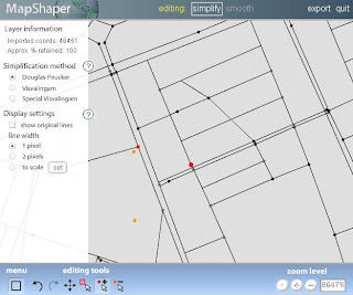
MapShaper

http://mapshaper.com/test/demo.html
shp yi upload et, editle, export et ve indir.


Database Browser

Database Browser programı Oracle, SqlServer ve MSaccess database lerine bağlanabiliyor.

http://www.dbsoftlab.com/Freeware/Database-Browser.html
 
DB Software Laboratory

pdf i html ye dönüştürme

  • linkteki exe yi indir.
http://pdftohtml.sourceforge.net/
http://sourceforge.net/projects/pdftohtml/
  • c:\ ye programı ve pdf i kopyala
  • komut istemini aç
  • pdftohtml -c c:\dosya.pdf c:\dosya.html yaz
pdf dosyasını html ye çevirip, internet explorer da açıp, google toolbarın sayfa yada kelime çeviricisi ile kullanılınca tadından yenmez.

Arcview ile kml yi shp ye dönüştürme

  • eğer Arcview 3.x demode oldu demezsen onu kur
  • burda bi avx var, onu indir ve arcview in ext klasörüne kopyala
  • arcview i açtığında extensions dan bu extension ı işaretle
  • ve açılan kml menüsünden dönüşümü yap.

fwtools ile kml ve shp arası dönüşüm

KML TO SHP:
  • fwtools kurulur
  • ogr2ogr.exe nin bulunduğu bin klasörü cmd de açılır
  • kml nin bulunduğu yol ve oluşturulmak istenen shp dosyasının yolu belirtilir
C:\Program Files\FWTools2.4.6\bin>ogr2ogr c:\b.shp c:\a.kml

SHP TO KML:

C:\Program Files\FWTools2.4.6\bin>OGR2OGR -F KML C:\B.KML C:\A.SHP

işte böyle. ayrıca;

C:\Program Files\FWTools2.4.6\bin>ogr2ogr.exe

yardımı ile FWTools Shell i kullanabilirsen, bu tool başka bir çok işe de yarıyor.

bi de şöyle bi yere rastladım.

http://www.gdal.org/ogr2ogr.html
UPDATE GEOYOL
SET ILCE_ADI='MELİKGAZİ'
WHERE MAH_ID=144;
select MAH_ID, MAX(OBJECTID)
FROM GEOYOL
GROUP BY MAH_ID
HAVING MAX (OBJECTID) > 9180;
select MAH_ID, SUM(UZUNLUK) FROM GEOYOL
GROUP BY MAH_ID
ORDER BY SUM(MAH_ID);

script

SELECT COUNT (*) FROM GEOYOL;
SELECT COUNT (MAH_ID) FROM GEOYOL;
SELECT SUM (OBJECTID) FROM GEOYOL;
SELECT CONCAT(CONCAT (YOL_ADI, ' '), TANITIM_KODU) YOL, YOL_ADI, ILCE_ADI
FROM GEOYOL
SELECT I.*, M.ILCE_ADI, M.ADI_NUMARASI, Y.YOL_ADI, Y.TANITIM_KODU, y.GELISMISLIK_TURU
FROM GEOYOL Y
JOIN GEOMAHALLE M
ON M.OBJECTID = Y.MAH_ID
JOIN GEOILCELER I
ON I.ILCE_ADI = M.ILCE_ADI
SELECT M.ILCE_ADI, M.ADI_NUMARASI, Y.YOL_ADI, Y.TANITIM_KODU, y.GELISMISLIK_TURU
FROM GEOYOL Y
JOIN GEOMAHALLE M
ON M.OBJECTID = Y.MAH_ID
WHERE M.ADI_NUMARASI = 'SERÇEÖNÜ'
ORDER BY Y.YOL_ADI
SELECT M.ILCE_ADI, M.ADI_NUMARASI, Y.YOL_ADI, Y.TANITIM_KODU, y.GELISMISLIK_TURU
FROM GEOYOL Y
JOIN GEOMAHALLE M
ON M.OBJECTID = Y.MAH_ID
SELECT TK_MH_AD, DEMO, ADI_NUMARASI

FROM geomahalle

WHERE ILCE_ADI = 'KOCASİNAN'
AND ADI_NUMARASI = 'SERÇEÖNÜ';
SELECT TK_MH_AD, DEMO, ADI_NUMARASI

FROM geomahalle

WHERE ILCE_ADI = 'KOCASİNAN' ;

tablodan tabloya veri aktarma

INSERT INTO KULLANCI_ADI.TABLO_A

( OBJECTID, ESKI_YOL_ADI, YOL_ADI_, UZUNLUK, ACIKLAMA, TANITIM_KODU, ILCE_ADI, MAHALLE_ADI, GELISMISLIK_TURU, MAH_ID, MAHKOD, TK, TASIT_YAYA, YOL_TPI, TK_MH_AD, DEMO, E_GELISMIS, MAHICINDE, BIRLESIK, POLY, CLLX, CLLY, CURX, CURY)

SELECT OBJECTID, ESKI_YOL_A, YOL_ADI, UZUNLUK, ACIKLAMA, TANITIM_KO, ILCE_ADI, MAHALLE_AD, GELISMISLI, MAH_ID, MAHKOD, TK, TASIT_YAYA, YOL_TPI, TK_MH_AD, DEMO, E_GELISMIS, MAHICINDE, BIRLESIK, POLY, CLLX, CLLY, CURX, CURY

FROM KULLANICI_ADI.TABLO_B

Union ve Merge

iki ayrı spatial netcad mdb dosyasını birleştirme

bunun için 2 ayrı yöntem var:


  • NetCAD de iki mdb ye bağlantı kurulur. verinin alınacağı bağlantıdaki tabloda alınması planlanan kolonun güncelleştirme koduna yazı denir ve tablo düzenlemeye başla denir. düzenlemeye başlamakla birlikte spatial veri ncz ye dönüşmüş olur. sayısallaştırma yöntemlerinden biri kullanılarak diğer bağlantıya ncz ye dönüşmüş olan veri aktarılır.

  • iki tablonun da şeması aynı olacak şekilde yapılarının aynı olması sağlanır. dbmanager ile şemalardan biri ve iki tablonun da verileri saklanır. şemalardan biri boş bir mdb ye yüklenir. verilerden ilki yüklenir, ikincisi de yüklenirken tablo adlarının aynı olmasına dikkat edilir.

tablolar birleştirilirken veri alma işleminin hata oluşturmaması için objectID kolonu değerlerinin çakışmaması gerekir. birinin bittiği değerden diğerinin devam etmesi için excel de hazırlanan objectID değerleri Access e kopyala yapıştır yöntemi ile eklenir.

definition query


vertex lere nokta atar

FeatureVerticesToPoints mah t:\SIL\MAH_NOKTA.SHP ALL

polygon ve polyline için.

çevreleyenden bilgi al

istenen sonucu vermiyor
SpatialJoin yo mah t:\SIL\CEVRELEYEN_01_INTERSECTS.SHP JOIN_ONE_TO_MANY KEEP_ALL FMAPPING INTERSECTS 0 DIST

çevreleyenden bilgi al

istenen sonucu tam olarak veriyor

SelectLayerByAttribute mah NEW_SELECTION " OBJECTID = 81 "
SelectLayerByLocation yo HAVE_THEIR_CENTER_IN mah 0 NEW_SELECTION
CalculateField_management yo demo_1 x PYTHON 'x = 81'
SelectLayerByAttribute mah CLEAR_SELECTION
SelectLayerByAttribute yo CLEAR_SELECTION

Split Line at Vertices (Data Management) (ArcInfo only)

yolları kırmak
http://webhelp.esri.com/arcgisdesktop/9.2/index.cfm?id=1543&pid=1529&topicname=Split_Line_At_Vertices_(Data_Management)

ObjectID kolonu problemi

arcGISte çizdikten sonra netcade veriyi atıp, bağlantı yöneticisinde akıllandırdığımızda objectID kolonunu ekleyip, içini dolduruyor.

aynı veriyi arcgise atıp güncellemeler yaptığımızda objectıd kolonunu silmeden netcade tekrar aktardığımızda problem oluyor. objectıd si dolu olmayan verileri netcade aktarmamış oluyor.

Flip (Çizgi Yönünü değiştirir)

http://webhelp.esri.com/arcgisdesktop/9.2/index.cfm?TopicName=Flipping_lines

ArcGIS Server 9.3 Web Help

http://support.esri.com/index.cfm?fa=knowledgebase.webHelp.agServer93

Select by Location: graphical examples

http://webhelp.esri.com/arcgisdesktop/9.2/index.cfm?topicname=select_by_location:graphical_examples

Spatial Join (Analysis)

http://webhelp.esri.com/arcgisdesktop/9.2/index.cfm?id=1100&pid=1096&topicname=Spatial_Join_(Analysis)

An overview of writing geoprocessing scripts

http://webhelp.esri.com/arcgisdesktop/9.2/index.cfm?TopicName=An_overview_of_writing_geoprocessing_scripts

How Import from CAD (Conversion) works

How Import from CAD (Conversion) works

Geoprocessing Quick Guide

http://webhelp.esri.com/arcgisdesktop/9.1/pdf/Geoprocessing_Quick_Guide.pdf


SpatialJoin <target_features> <join_features> <out_feature_class> {JOIN_ONE_TO_ONE JOIN_ONE_TO_MANY} {KEEP_ALL KEEP_COMMON} {field_mapping} {INTERSECTS IS_WITHIN CONTAINS} {search_radius}


Buffer <in_features> <out_feature_class> <buffer_distance_or_field> {FULL LEFT RIGHT} {ROUND FLAT} {NONE ALL LIST} {dissolve_field;dissolve_field...}


Frequency <in_table> <out_table> <frequency_fields;frequency_fields...> {summary_ields; summary_fields...}


rasterto...


TableToDBASE <input_tables;input_tables...> <output_folder>


PolygonToRaster <in_features> <value_field> <out_raster_dataset> {CELL_CENTER MAXIMUM_AREA MAXIMUM_COMBINED_AREA} {priority_field} {cellsize}


Split <in_cover> <split_cover> <split_item> <path> {POLY LINE POINT NET LINK RAW} {fuzzy_tolerance}


Buffer <in_cover> <out_cover> {LINE POLY POINT NODE} {buffer_item} {buffer_table}
{buffer_distance} {fuzzy_tolerance} {ROUND FLAT} {FULL LEFT RIGHT}


Ungenerate: Creates a text file of xy coordinates from a coverage.


Ungenerate <in_cover> <out_generate_file> <LINE POINT POLY TIC LINK REGION.subclass ANNO.subclass> {NODES NO_NODES} {EXPONENTIAL FIXED}


duble yolları tek yol yapmak için:
Collapse Dual Lines to Centerline: Derives centerlines (single lines) from dual-line features, such as road casings, based on specified width tolerances.


CollapseDualLineToCenterline <in_cover> <out_cover> <maximum_width> {minimum_width}


mahalle sınırlarından ilçe sınırı üretmek için kullanılır:
Dissolve: Merges adjacent polygons, lines, or regions that have the same value for a specified item.


Dissolve <in_cover> <out_cover> <dissolve_item> {POLY LINE NET REGION.subclass}


SpatialJoin <target_features> <join_features> <out_feature_class> {JOIN_ONE_TO_ONE
JOIN_ONE_TO_MANY} {KEEP_ALL KEEP_COMMON} {field_mapping} {INTERSECTS IS_WITHIN CONTAINS} {search_radius}


Buffer <in_features> <out_feature_class> <buffer_distance_or_field> {FULL LEFT RIGHT} {ROUND FLAT} {NONE ALL LIST} {dissolve_field;dissolve_field...}


Eliminate: Merges selected polygons with neighboring polygons that have the largest shared border between them or the largest area.


Eliminate <in_cover> <out_cover> <info_express;info_express...> {NO_KEEP_EDGE KEEP_EDGE} {POLY LINE} {selection_file} {BORDER AREA}


Simplify Line or Polygon: Removes small fluctuations or extraneous bends from a line or polygon, while preserving its essential shape.


SimplifyLineOrPolygon <in_cover> <out_cover> <simplification_tolerance> {POINT_REMOVE BEND_SIMPLIFY} {NO_ERROR_CHECK ERROR_CHECK}


Join Info Tables: Joins the item definitions and values of two tables based on a shared item.


JoinItem <in_info_table> <join_info_table> <out_info_table> <relate_item> {start_item}
{LINEAR ORDERED LINK}


dönüşüm:
Transform: Moves all features in the coverage based on a set of from and to control points.


Transform <in_cover> <out_cover> {AFFINE PROJECTIVE SIMILARITY}


x ve y koordinatlarını yazar:
Add XY Coordinates: Calculates and adds xy coordinates of labels or points to the coverage PAT or xy coordinates of nodes to the coverage NAT.


AddXY <in_cover> {POINT NODE}


Renumber Nodes: Updates arc–node topology by renumbering nodes for coverage arcs and identifies arcs that share the same node locations.


Renode <in_cover> {from_item} {to_item}


Create Coverage: Creates a new, empty coverage.


Create <out_cover> {template_cover}


Create Fishnet: Creates a fishnet of rectangular cells.


CreateFishnet <out_feature_class> <origin_coord> <y_axis_coord> <cell_width> <cell_height> <number_rows> <number_columns> {corner_coord} {LABELS NO_LABELS} {template}


Add XY Coordinates: Adds the fields POINT_X and POINT_Y to the point input features and calculates their values.


AddXY <in_features>


geometri yi kontrol eder:


Check Geometry: Checks the validity of the geometries of features.


CheckGeometry <in_features;in_features...> <out_table>


• The Output table will have one record for each problem found. If no problems are found, the Output table will have no records.


• The Output table has the following fields:


• CLASS—The full path to and name of the feature class in which the problem was found.


• FEATURE_ID—The Feature ID (FID) or Object ID (OID) for the feature with the geometry problem.


• PROBLEM—A short description of the problem.


• The PROBLEM field will contain one of the following: Short segment, Null geometry, Incorrect ring
ordering, Incorrect segment orientation, Self intersections, Unclosed rings,or Empty parts.


• For multipoint features, only the null geometry and empty part problems apply.


• For point features, only the null geometry problem applies.


Copy Features: Copies the selected features to a new feature class.


CopyFeatures <in_features> <out_feature_class> {configuration_keyword} {spatial_grid_1} {spatial_grid_2} {spatial_grid_3}


Delete Features: Deletes features from the input feature class or layer


DeleteFeatures <in_features>


bina poligonuna nokta ekler, centroid:


Feature to Point: Creates a point feature class based on an input polygon, line, or multipoint feature class.


FeatureToPoint <in_features> <out_feature_class> {CENTROID INSIDE}


• If the Input Features are polygons, the Centroid option will result in points which are at the center of gravity for that polygon. This may NOT actually be inside the polygon's area. To insure that the point created is inside the polygon's area, use the Inside option.


• If the Input Features are lines and the Centroid option is used the output points will be coincident with the center of the feature's envelope (rectangular window that contain a specific feature). If the Inside option is used, the point on the line closest to the center of the feature's envelope will be used.


• If the Input Features are multipoint and the Centroid option is used the output points will be coincident with the center of the feature's envelope (rectangular window that contain a specific feature). If the Inside option is used, the point (part of the multipoint) closest to the center of the feature's envelope will be used.


vertex lere nokta atar:


Feature Vertices to Points: Creates a point feature class from the vertex locations of the input features.


FeatureVerticesToPoints <in_features> <out_feature_class>
{ALL MID START END BOTH_ENDS}


Multipart to Singlepart: Breaks any multipart features into single features.


MultipartToSinglepart <in_features> <out_feature_class>


yolları kırmak için:
Split Line at Vertices: Splits each line feature at every vertex contained in a feature class.


SplitLine <in_features> <out_feature_class>


Select Layer by Attribute: Creates, updates, or removes the selection on a layer or table view using an attribute query.


SelectLayerByAttribute <in_layer_or_view> {NEW_SELECTION ADD_TO_SELECTION REMOVE_FROM_SELECTION SUBSET_SELECTION SWITCH_SELECTION CLEAR_SELECTION} {where_clause}


• The input must be a feature layer or a table view. It cannot be a feature class or table.


• This tool is not limited to working in ArcMap; it works on layers and table views in ArcCatalog and in scripts. The Make Feature Layer tool makes a layer for a feature class, and the Make Table View tool does the equivalent for a table.


• If an extent or a definition query is present on the input layer or table view, only those features or rows that match the extent and/or definition query will be available to be selected.


Select Layer by Location: Creates, updates, orv removes a selection on the input layer based on spatial relationships to select features.


SelectLayerByLocation <in_layer> {INTERSECT WITHIN_A_DISTANCE COMPLETELY_CONTAINS COMPLETELY_WITHIN HAVE_THEIR_CENTER_IN SHARE_A_LINE_SEGMENT_WITH BOUNDARY_TOUCHES ARE_IDENTICAL_TO CROSSED_BY_THE_OUTLINE_OF CONTAINS CONTAINED_BY} {select_
features} {search_distance} {NEW_SELECTION ADD_TO_SELECTION REMOVE_FROM_SELECTION SUBSET_SELECTION SWITCH_SELECTION}


• The input must be a feature layer or a table view. It cannot be a feature class or table.


• This tool is not limited to working in ArcMap; it works on layers and table views in ArcCatalog and in scripts. The Make Feature Layer tool makes a layer for a feature class, and the Make Table View tool does the equivalent for a table.


• If an extent or a definition query is present on the input layer or table view, only those features or rows that match the extent and/or definition query will be available to be selected.


çevreleyenden bilgi al

selectLayerByAttribute: mah_ıd si 100 olan mahalle seçilir,


SelectLayerByLocation : seçili mahalle içindeki yollar seçilir (have their center in)


CalculateField: yol un mahalle ID si 100 yazdırılır.


alan hesaplaması:
Calculate Areas: Calculates area values for each feature in a polygon feature class.


CalculateAreas &lt;input_feature_class&gt; &lt;output_feature_class&gt;


• This tool is useful in determining a weight for intrazonal interaction.


• The field F_AREA is created in the output feature class to store calculated Area values. If a field of this
name already exists in the input feature class, it will be overwritten in the output feature class.


projeksiyon oluşturma:
Create Spatial Reference: Creates a spatial reference object for use in ModelBuilder and scripting.


CreateSpatialReference {spatial_reference} {spatial_reference_template} {xy_domain} {z_domain} {m_domain} {template;template...} {expand_ratio}


• Setting the Spatial Reference sets the coordinate system, spatial domains, and precision. The spatial domains and precision of the output spatial reference can be further modified using XY Domain, Z Domain, M Domain, Template XYDomains, and Grow XYDomain By Percentage.


• Template XYDomains does not have to be in the same coordinate system as that specified in Spatial Reference or Spatial Reference Template. If they are different, the extents will be projected to match.


Project:v Changes the coordinate system of your Input Dataset or Feature Class to a new Output Dataset or Feature Class with the newly defined coordinate system, including the datum and spheroid.


Project <in_dataset> <out_dataset> <out_coordinate_system> {transform_method;
transform_method...} {in_coordinate_system}


• All input feature classes and/or feature layers are valid inputs to this tool.


• If you have a feature class that does not have a defined projection and PRJ file, then use the DefineProject tool first.


Project Raster: Transforms a raster dataset from one projection to another.
ProjectRaster <in_raster> <out_raster> <out_coordinate_system> {NEAREST BILINEAR CUBIC} {cell_size} {geographic_transform;geographic_transform...} {registration_point}


rasterdan bir bölümü kesip almak için:
Clip: Creates a rectangular spatial subset of a raster dataset.


Clip <in_raster> <rectangle> <out_raster> {in_template_raster}


• The Clip tool allows you to extract a portion of a raster dataset based on a rectangular extent.


• The minimum and maximum x and y extents allow you to define the clip extents for your output raster dataset.


• The extent values must be in the same spatial coordinates and units as the raster dataset.


Copy Raster: Converts a raster to a BMP, GIF, GRID, IMG, JPEG, JPEG2000, PNG, TIFF, or a geodatabase raster dataset, and can be used to load raster datasets into a raster catalog.


CopyRaster <in_raster> <out_raster_dataset> {configuration_keyword} {background_value} {nodata_value} {NONE ONEBITTO8BIT} {NONE COLORMAPTORGB} {1_BIT 2_BIT 4_BIT 8_BIT_UNSIGNED 8_BIT_SIGNED 16_BIT_UNSIGNED 16_BIT_SIGNED 32_BIT_UNSIGNED 32_BIT_SIGNED 32_BIT_FLOAT 64_BIT}


Copy Rows: Writes the rows from an input table, table view, feature class or feature layer to a new table.
CopyRows <in_rows> <out_table> {configuration_keyword}


verilerin en çok toplandığı orta noktayı belirler:
Central Feature: Identifies the most centrally located feature in a point, line, or polygon feature.


CentralFeature <input_feature_class> <output_feature_class> <EUCLIDEAN DISTANCE MANHATTAN DISTANCE> {weight_field}{self_potential_weight_field}


Linear Directional Mean: Identifies the general (mean) direction for a set of lines.
DirectionalMean <input_feature_class> <output_feature_clas> <orientation_only>
{case_field}


ulaşım ile ilgili:
Make Closest Facility Layer: Makes a closest facility network analysis layer and sets its navigation properties.
MakeClosestFacilityLayer <in_network_dataset> <out_network_analysis_layer>
<impedance_attribute> {TRAVEL_TO TRAVEL_FROM} {default_cutoff} {default_number facilities_to_find} {accumulate_attribute_name; accumulate_attribute_name...} {ALLOW_UTURNS NO_UTURNS ALLOW_DEAD_ENDS_ONLY} {restriction_attribute_name;
restriction_attribute_name...} {USE_HIERARCHY NO_HIERARCHY} {hierarchy_settings}
{TRUE_LINES_WITH_MEASURES NO_LINES STRAIGHT_LINES TRUE_LINES_WITHOUT_MEASURES}


• A Closest Facility layer can be made on a network currently added to the ArcMap table of contents or you can browse to a network dataset on disk.


• Hierarchy options can only be set if the input analysis network has a hierarchy attribute.
Network
Analyst
toolbox

Make OD Cost Matrix Layer: Makes an origin and destination cost matrix layer and sets its navigation properties.


MakeODCostMatrixLayer <in_network_dataset> <out_network_analysis_layer>
<impedance_attribute> {default_cutoff} {default_number_destinations_to_find}
{accumulate_attribute_name; accumulate_attribute_name...} {ALLOW_UTURNS NO_UTURNS ALLOW_DEAD_ENDS_ONLY} {restriction_attribute_name; restriction_attribute_name...} {USE_HIERARCHY NO_HIERARCHY} {hierarchy_settings} {STRAIGHT_LINE NO_LINES}


• An OD Cost Matrix layer can be made on a network currently added to the ArcMap Table of Contents or on a network dataset on disk.


• Hierarchy options can only be set if the input analysis network has a hierarchy attribute.


Make Route Layer: Makes a route network analysis layer and sets its navigation properties.
MakeRouteLayer <in_network_dataset> <out_network_analysis_layer> <impedance_attribute>
{USE_INPUT_ORDER FIND_BEST_ORDER} {PRESERVE_BOTH PRESERVE_NONE PRESERVE_FIRST PRESERVE_LAST} {NO_TIMEWINDOWS USE_TIMEWINDOWS} {accumulate_attribute_name;accumulate_attribute_name...} {ALLOW_UTURNS NO_UTURNS ALLOW_DEAD_ENDS_ONLY}
{restriction_attribute_name;restriction_attribute_name...} {USE_HIERARCHY NO_
HIERARCHY} {hierarchy_settings} {TRUE_LINES_WITH_MEASURES NO_LINES STRAIGHT_LINES TRUE_LINES_WITHOUT_MEASURES} {start_date_time}


• The Route layer can be made on a network currently added to the ArcMap Table of Contents or on a network dataset on disk.


• Hierarchy options can only be set if the input analysis network has a hierarchy attribute.


ArcGIS te Calculate Hatası

Bu hatayı verdikten sonra doldurması gereken kolonun tamamını doldurmuyor. ama veriler parça parça seçilerek doldurulmak istendiğinde aynı uyarı mesajını verse de seçilen verilerin ilgili kolonunu dolduruyor.

Kolon Birleştirmek

NetCAD de bağlantı yöneticisi kullanılarak 2 adete kadar kolon birleştirebilmek mümkün olabiliyor. ancak sql komutu yardımıyla 2 den fazla kolon birleştirebilmek mümkün.
ArcGIS'ta field calculator kullanılarak 2 den fazla kolon birleştirebilmek mümkün.

kaydetme

ArcGIS'ta proje kaydedildiğinde bütün ayarlar kaydedilmiş oluyor.

NetCAD'de ise bağlantı yöneticisi, Referans yöneticisi, veri sözlüğü ve Proje.ncz dosyasının ayrı ayrı kaydedilmesi gerekiyor.

ArcGIS'teki join ve relates durumu da projenin kaydedilmesiyle kaydoluyor.

etiketleme

veriye ait tablodaki bilgiler etiket olarak yazdırıldığında, pan yapılması halinde yazılar ekranda uygun bir konumda gösterilmeye devam etmiyor. sabit olarak tek noktada kalıyor. arcGIS'ta ise etiketler ekranı takip ediyor.

Labels - Etiketler

3D (14) 3D Analyst (5) 3D Studio Max (2) ABD (2) About building an SQL expression (1) Access (4) Adding hyperlinks to features (1) Adding OLE DB connections (1) administrative areas (1) Adobe (1) Adobe illustrator (1) Adobe Reader (1) Adobe Reader Analysis Tool (1) aggregate (1) Aggregate Polygons (2) An overview of ModelBuilder (1) An overview of writing geoprocessing scripts (2) analysis (2) Append (4) ArcCatalog (1) ArcGIS (63) ArcGIS 9.3 Map Export PDF (2) ArcGIS Mobile (1) ArcGIS Server (9) ArcGIS Server 9.3 Web Help (1) Arcgis Server 10 (2) Architectural (1) arcscene (3) arcscripts (5) ArcSDE (1) Arcview (1) Arcview ile kml yi shp ye dönüştürme (1) AutoCAD (2) AutoVue (1) Bina Verisini Düzenlerken (2) bölme (1) CAD (3) CAD/GIS (87) calculate (1) canada data (2) CenterPoint (1) Chicago (2) CityEngine (1) CitySurf (5) clip (1) Common line editing tasks (1) Common polygon editing tasks (1) Contour (1) Create Node (1) çevreleyenden bilgi al (2) database (1) Database Browser (1) date (1) definition query (1) demicron (1) Dissolve (1) download (6) dünya (1) dwg (1) Eğim Analizi (1) Eliminate (1) English (67) Erciyes (4) error (1) Esri (2) Eşyükselti (1) etiket (1) Excel (4) export (1) expression (2) Flip (Çizgi Yönünü değiştirir) (2) Free GIS Software (1) freeWRL (2) fwtools (1) fwtools ile kml ve shp arası dönüşüm (1) FWTools Shell (1) Geomedia (14) Geoprocessing Quick Guide (1) geoserver (3) geoserver kurulumu (1) geoserver labeling (2) geoserver labeling not supported with qgis (1) Geoyol u düzenlerken (1) GIS Data (2) GIS Data of America (2) Glonet (1) google (1) group by (1) halihazır (1) hidroloji (1) How Import from CAD (Conversion) works (1) html (1) hydrology (10) hyperlink (1) hystorical GIS (1) ilk karakteri silen sql (1) insert (2) intersect (1) İzohips (1) java (2) kml (2) kml to shp (3) konya (1) label (2) line editing (1) Link (1) links (40) M and Z Values (3) MapBuilder (1) Maplex Label Engine (1) Maps (1) MapShaper (1) Max (1) MBR (1) mdb (1) Mekansal Analiz (1) merge (1) Mimari (1) Mobile (1) multi Geometry (3) multipart to single part (1) multipoint (1) NetCAD (19) netcad Network Lisans İzleyicisi (1) Netcad Program No (1) Netcad TILE (1) NetCAD to Oracle Spatial (5) NetCAD ve ArcGIS farkı (3) netcadde wms oluşturmak için workspace export (1) netgis (1) netgis server (1) Network Analyst (3) Node (1) ObjectID kolonu problemi (1) online wms viewer (1) Oracle (16) Oracle Spatial (3) Oracle veri tabanının yeniden başlatılması (1) output mode (1) Parcel (2) Parcel Editor (1) parsel (1) pdf (3) pdf i html ye dönüştürme (1) pdftohtml (1) PHP (1) point (1) PostGIS (30) Postgresql (8) Postgresql otomatik yedek alma (1) Projection (1) Pyton (1) Raster (2) register (1) Rename (1) RepairGeometry (1) replace (2) Routing (1) sdelayer (1) Select by Location: graphical examples (1) server (1) shape viewer (2) shp (7) shp2sdo (1) single Geometry (3) sld (1) snap (1) social explorer (1) sonra eklenecek (1) Spatial Join (Analysis) (2) spatialanalysisonline (1) Split Line at Vertices (Data Management) (ArcInfo only) (1) Sql (48) SQL reference (1) SRID (1) su yatakları (1) subst (1) subtract (1) sum (1) synchronize (1) Şehir ve Bölge Planlama (1) tablo (1) tablodan tabloya veri aktarma (1) terrain (1) Texas (2) time (1) tin (3) tin edit (1) topology (5) Topology check (2) Traffic Simulation (1) Trafik (1) Transform (1) trim (1) Ulaşım (1) Ulaşım Planlama (1) union (1) Union ve Merge (1) Unregister As Versioned (1) update (2) UrbanSim (1) veri (2) Vermont (1) Versioning (2) vertex lere nokta atar (1) video (17) WFS (2) wirefusion (1) wms (3) wmware (1) wmx (1) Working with Microsoft Access files in ArcGIS (1) Working with Microsoft Excel files in ArcGIS (1) world (1) wrl (1) yol (2) yol kırma (2) Yol Uzunluk (2) yolkır (1) Z değeri edit (1)