ArcGIS etiketine sahip kayıtlar gösteriliyor. Tüm kayıtları göster

You must copy the latest ST_GEOMETRY and dependent libraries to the PostgreSQL software location

Problem:
Create Enterprise Geodatabase Error

https://geonet.esri.com/thread/56840

SOLUTION:
Place the ST_Geometry libraries in the PostgreSQL lib directory

Geodatabase creation in PostgreSQL relies on the presence of the ST_Geometry library. You must place the appropriate library in the lib directory where PostgreSQL is installed before you can create a geodatabase. ST_Geometry libraries can be found in the DatabaseSupport folder of your ArcGIS client installation.

Since this tutorial assumes your PostgreSQL installation is on a Windows server, you will use the ST_Geometry library found in the Windows64 folder.
Steps:

In Windows Explorer, navigate to the location of the Windows ST_Geometry library in your ArcGIS client installation directory.

The default location for ArcGIS for Desktop on 64-bit Windows operating systems is C:\Program Files (x86)\ArcGIS\Desktop\DatabaseSupport\PostgreSQL\Windows64; on 32-bit Windows operating systems, it is C:\Program Files\ArcGIS\Desktop\DatabaseSupport\PostgreSQL\Windows64.
Copy st_geometry.dll from this location.
Navigate to the PostgreSQL lib directory on the database server and paste the library to that location.

On Windows, the default location is C:\Program Files\PostgreSQL\9.0\lib.

3D Analyst – An Introduction

3D Analyst - Working with Terrain Datasets

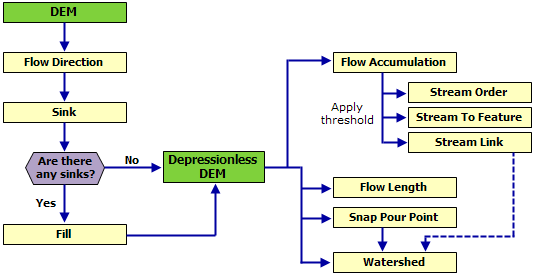
dem verisinden su yataklarını bulma


1. dem verisini al

2. flow dir oluştur

3. flow accumulation oluştur

4. raster to point oluştur

5. pointin tematiğini ayarla

CREATE TIN FROM RASTER


High quality Video

Remove Z- and/or M-values from a feature class

http://support.esri.com/en/knowledgebase/techarticles/detail/35818

Procedure

Browse to ArcToolbox > Conversion Tools > To Geodatabase.
Open the Feature Class to Geodatabase (multiple) tool.
Add all the feature classes into the Input Feature Class parameter.
Select an Output Geodatabase.
Click the Environments button at the bottom of the tool dialog box.
Expand the General Settings.
For the parameter, Output has Z Values, change the value to Disabled.
For the parameter, Output has M Values, change the value to Disabled.
Click OK in the Environments dialog box.
Click OK to execute the geoprocessing tool.

sdelayer register 9.3


sdelayer -o register -l KBBSREHBER,GEOM -e p -t SDO_GEOMETRY -g NONE -u ARCCBS -p ARCCBS -C CBNO -P HIGH

sdelayer -o register -l UNIV_YOL,GEOM -e l -t SDO_GEOMETRY -g NONE -u ARCDATA -p K -C CBNO -P HIGH

sdelayer -o alter -l UNIV_MAHALLE,GEOM -u ARCDATA -p ARCDATA -E calc -g NONE 


=======


C:\>sdelayer -o register -l UNIV_YOL,GEOM -e l -t SDO_GEOMETRY -g NONE -u ARCDATA -p K -C fid -P HIGH

sdelayer -o register -l UNIV_MAHALLE,GEOM -e a -t SDO_GEOMETRY -g NONE -u ARCDATA -p K -C fid -P HIGH

ArcGIS For AutoCAD


ArcGIS for AutoCAD
Download
If you missed anything in the live broadcast, watch the recorded seminar.
If you are interested in additional training, visit Esri Training for detailed course descriptions, class schedules, and registration information.

ESRI ArcGIS 10: Mobile GIS in ArcGIS 10


Configuring an ArcMap edit session to perform nonversioned edits

versiyonlama işini iptal etmek işimize gelebilir ve hatta versiyonlama bizim için dezavantaj oluşturabilir. onun için şu linkte anlatılan bi şeyler var:

http://webhelp.esri.com/arcgisserver/9.3/java/index.htm#geodatabases/config-1460220541.htm

yönergeler uygulanırsa versiyonlama iptal edilmiş olur.

arccatalog da versiyonlama açılmış ise, arcmap te de versiyonlama etkinleştirilerek, veri düzenlenebilir. arccatalog da versiyonlama yapılmadıysa arcmapte versiyonlanarak veri düzenlenemez. versiyonlamadan veriyi dzenlemek gerekir.


Intersect - Create Node

Intersect yolek_kbbsyol_Merge_kirik c:\temp\intersect.shp ALL 0.005 POINT

Creates Nodes


network analyst "error: out of memory"

network analyst "error: out of memory" hatası alırsan,

http://support.esri.com/en/knowledgebase/techarticles/detail/30759 

yani bu hatayı alma nedeni networkün çok büyük yada yoğun olmasıdır. networku küçültmek ya da yoğunluğunu azaltmak çözüm olacaktır.

3 Boyutlu Modelleme

1. polyline geometrisinde yükseklik bilgisi olan ed50 koordinat sisteminde veri ile başlanır.

2a. tin oluşturulur

2b. oluşturulmuş tin

2c. eğim analizi eklenir

3.veriler arcscene de açılır.

4.hazırlanan raster verilere base height verilerek export edilir.

verinin geometrisi repair edilmeden topoloji oluşturulması halinde hata


Verinin ilk hali

 veri repair edilmeden topoloji oluşturulursa, aslında var olmayan bir hata varmış gibi görünüyor.

veri repair edilerek topoloji oluşturulursa topolojik hata oluşmuyor.

Field Calculator (Mid)

http://arcscripts.esri.com/details.asp?dbid=13527
bir field daki belirlenen sayıdaki karakteri calculate eder. faydalı bir eser.

Network Analyst

şu network analiz işine bi bakalım.

öncelikle bu yol verisinde 'Shape_leng' isimli bir kolon açarak uzunluk değerlerini metre cinsinden
yazdırıyoruz.

ikinci işlem olarak modelimizi çalıştırıyoruz. fr_to2 ve to_fr2 kolonlarını da ekleyip update ettikten sonra
sonuç olarak elimizde ekteki şablona benzer bir veri yapısı oluşmalı.


--4 oluşan tablo yapısı--

Network Analiz de kullanacağımız verimiz artık hazır.

tools menüsünde extensionlar komutuyla Network Analyst Extensionunun açık olduğundan emin olalım.
shp verisini Personal Geodatabase içinde oluşturduğumuz bir feature class içine atalım. bu işi neden yaptık?
extension ın çalışması için bu şart.

sarı kutu açılır. PGD içinde yeni bir network oluşturulur.

network oluşturulurken, yada oluşturduktan sonra 0,1,2,3 ekran alıntılarındaki gibi ayarlar yapılır. yon
bilgisini networkte tanımlamak için 2 adet kolon (fr_to, to_fr) kullanıldı. 


-- 0123--
ve ArcMAP te bu network açılır.
Network Analyst Menusu:

--5--


New Route: verilen noktalar arasında kısa yol bulur


New Service Area:


New Closest Facility: en yakın faaliyet alanını hesaplar


New OD Cost Matrix:


New Vehicle Routing Problem:
ekran görüntüsü yok

CitySurf kaynaklı snapsizliğin 1 m. altında olduğu yolların düzeltilmesinde ArcGIS Topolojide de trim yerine snap kullanmak

Çizgi geometrisindeki bir kaydı ikinci bir kayıt iki ayrı noktadan kesiyorsa ve topoloji oluşturduktan sonra düzeltmek için trim seçeneğini kullandığımızda ArcGIS 9.3.1 hata vererek kapanıyordu. Trim yerine snap seçeneğini kullanarak veriyi düzelterek problem çözüme kavuşturulmuş oldu.


Labels - Etiketler

3D (14) 3D Analyst (5) 3D Studio Max (2) ABD (2) About building an SQL expression (1) Access (4) Adding hyperlinks to features (1) Adding OLE DB connections (1) administrative areas (1) Adobe (1) Adobe illustrator (1) Adobe Reader (1) Adobe Reader Analysis Tool (1) aggregate (1) Aggregate Polygons (2) An overview of ModelBuilder (1) An overview of writing geoprocessing scripts (2) analysis (2) Append (4) ArcCatalog (1) ArcGIS (63) ArcGIS 9.3 Map Export PDF (2) ArcGIS Mobile (1) ArcGIS Server (9) ArcGIS Server 9.3 Web Help (1) Arcgis Server 10 (2) Architectural (1) arcscene (3) arcscripts (5) ArcSDE (1) Arcview (1) Arcview ile kml yi shp ye dönüştürme (1) AutoCAD (2) AutoVue (1) Bina Verisini Düzenlerken (2) bölme (1) CAD (3) CAD/GIS (87) calculate (1) canada data (2) CenterPoint (1) Chicago (2) CityEngine (1) CitySurf (5) clip (1) Common line editing tasks (1) Common polygon editing tasks (1) Contour (1) Create Node (1) çevreleyenden bilgi al (2) database (1) Database Browser (1) date (1) definition query (1) demicron (1) Dissolve (1) download (6) dünya (1) dwg (1) Eğim Analizi (1) Eliminate (1) English (67) Erciyes (4) error (1) Esri (2) Eşyükselti (1) etiket (1) Excel (4) export (1) expression (2) Flip (Çizgi Yönünü değiştirir) (2) Free GIS Software (1) freeWRL (2) fwtools (1) fwtools ile kml ve shp arası dönüşüm (1) FWTools Shell (1) Geomedia (14) Geoprocessing Quick Guide (1) geoserver (3) geoserver kurulumu (1) geoserver labeling (2) geoserver labeling not supported with qgis (1) Geoyol u düzenlerken (1) GIS Data (2) GIS Data of America (2) Glonet (1) google (1) group by (1) halihazır (1) hidroloji (1) How Import from CAD (Conversion) works (1) html (1) hydrology (10) hyperlink (1) hystorical GIS (1) ilk karakteri silen sql (1) insert (2) intersect (1) İzohips (1) java (2) kml (2) kml to shp (3) konya (1) label (2) line editing (1) Link (1) links (40) M and Z Values (3) MapBuilder (1) Maplex Label Engine (1) Maps (1) MapShaper (1) Max (1) MBR (1) mdb (1) Mekansal Analiz (1) merge (1) Mimari (1) Mobile (1) multi Geometry (3) multipart to single part (1) multipoint (1) NetCAD (19) netcad Network Lisans İzleyicisi (1) Netcad Program No (1) Netcad TILE (1) NetCAD to Oracle Spatial (5) NetCAD ve ArcGIS farkı (3) netcadde wms oluşturmak için workspace export (1) netgis (1) netgis server (1) Network Analyst (3) Node (1) ObjectID kolonu problemi (1) online wms viewer (1) Oracle (16) Oracle Spatial (3) Oracle veri tabanının yeniden başlatılması (1) output mode (1) Parcel (2) Parcel Editor (1) parsel (1) pdf (3) pdf i html ye dönüştürme (1) pdftohtml (1) PHP (1) point (1) PostGIS (30) Postgresql (8) Postgresql otomatik yedek alma (1) Projection (1) Pyton (1) Raster (2) register (1) Rename (1) RepairGeometry (1) replace (2) Routing (1) sdelayer (1) Select by Location: graphical examples (1) server (1) shape viewer (2) shp (7) shp2sdo (1) single Geometry (3) sld (1) snap (1) social explorer (1) sonra eklenecek (1) Spatial Join (Analysis) (2) spatialanalysisonline (1) Split Line at Vertices (Data Management) (ArcInfo only) (1) Sql (48) SQL reference (1) SRID (1) su yatakları (1) subst (1) subtract (1) sum (1) synchronize (1) Şehir ve Bölge Planlama (1) tablo (1) tablodan tabloya veri aktarma (1) terrain (1) Texas (2) time (1) tin (3) tin edit (1) topology (5) Topology check (2) Traffic Simulation (1) Trafik (1) Transform (1) trim (1) Ulaşım (1) Ulaşım Planlama (1) union (1) Union ve Merge (1) Unregister As Versioned (1) update (2) UrbanSim (1) veri (2) Vermont (1) Versioning (2) vertex lere nokta atar (1) video (17) WFS (2) wirefusion (1) wms (3) wmware (1) wmx (1) Working with Microsoft Access files in ArcGIS (1) Working with Microsoft Excel files in ArcGIS (1) world (1) wrl (1) yol (2) yol kırma (2) Yol Uzunluk (2) yolkır (1) Z değeri edit (1)